
OVERVIEW
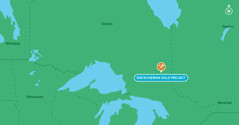
The Matachewn Gold project is a joint venture with O3 Mining Inc. (formerly Alexandra Minerals) and District Copper Corp. The joint venture is shared on a 50:50 basis, with O3 acting as Operator of the Joint Venture. The project consists of 86 single and boundary cells (1,328 hectares) located in the southwest portion of the Cairo Township in the Timiskaming Mining District in the Province of Ontario, NTS sheet 41P/15. The project is located approximately 5 kms east of Alamos Gold Inc’s Young Davidson gold mine and 1.5km east of the town of Matachewan. The property is subject to a 3% net smelter royalty on production.
Gold Producers
The past producing Matachewan Consolidated Mine and the Young Davidson Mine are located approximately 5 kms west of the Matachewan property. Both mines show a spatial relationship to the Larder Lake-Cadillac Break.
The Young Davidson mine is expected to produce between 180,000 -190,000 ounces of gold in 2019 (Alamos Gold’s 2019 production guidance). The 2019 proven and probable reserves for the Young Davidson mine is quoted by Alamos Gold to be 3.26 million ounces of gold.
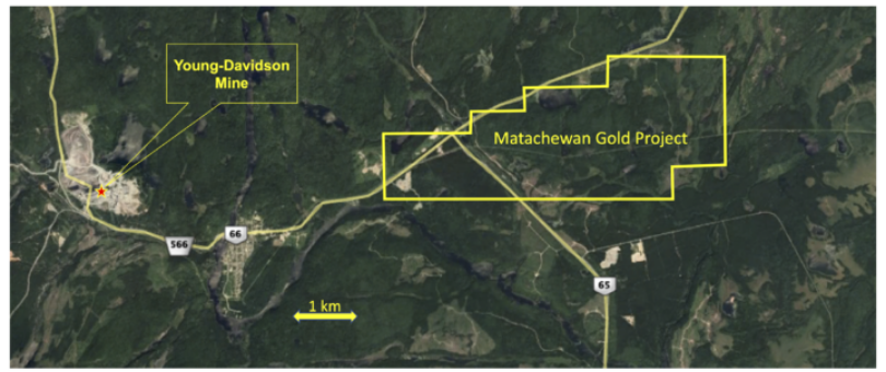
Matachewan Project - 5km east of Alamos Gold's Young Davidson gold mine
Exploration Model
The property lies within the southwest portion of the Abitibi Greenstone belt with gold being of prime significance in the Val D’Or, Cadillac, Rouyn-Noranda, Kirkland Lake, and Matachewan areas. Of importance to the gold camps is the Larder Lake-Cadillac Break (LLCB), which either hosts or is associated with the gold mineralization.
The exploration model is gold, bearing sulphide mineralization similar to the Matachewan Consolidated Mine and the Young Davidson Mine within shear hosted, sub-vertical, silica and carbonate altered structures in mafic volcanic and syenitic and dioritic intrusives associated with the Larder Lake-Cadillac Break.
Geology
The property covers an assemblage of mafic to ultra-mafic volcanic rocks with felsic and interflow sedimentary units which have been intruded by a conformable mafic to ultramafic body to the west and numerous porphyritic syenitic to quartz diorite intrusive units to the east. A north-south trending Matachewan diabase dike swarm similar to that which occurs on the Young Davidson property occurs from the center to the east side of the property.
Exploration Results/Mineralization
Two principal types of gold mineralization occur within the Matachewan Camp. The first one consists of free gold and gold bearing pyrite in pyritic quartz stringers and altered wall rocks (Matachewan Consolidated Mine). The second type consists of gold bearing pyritic quartz veinlets hosted in porphyritic syenitic intrusives (Young Davidson Mine).
The Matachewan area was first explored in 1875. In 1981 Newmont Exploration of Canada Ltd. exploration of the property reported gold assays of chert containing abundant fine-grained pyrite in proximity to grey porphyritic syenites as 2,500 ppb (2.5g/t) and 5,900 ppb (5.9g/t) over 2 meter samples from trench 9A and grab samples of 64,800 ppb (64.8g/t), 14,400 ppb (14.4 g/t), 2,380 ppb (2.38g/t) and 940 ppb and 690 ppb from the bedrock around trench 9A.(Brisbin 1981).
Exploration completed by District prior to formation of the joint venture was limited to a surface sampling program, a ground geophysical survey (of limited extent) and a small diamond drilling program This work located gold mineralization in quartz veins in mafic volcanics, in weakly pyritic altered volcanics, iron formation, pyritic interflow sediments, green carbonate altered zones and in weakly pyritic syenite intrusives. Two rock chip samples collected from volcanic breccia assayed 1445ppb (1.45g/t) and 1090ppb (1.09 g/t) each over a 3m interval.
The geophysical survey completed by District defined eleven targets within the property that exhibit chargeability, resistivity and magnetic signatures.
The diamond drilling program completed in 2008 intersected the following mineralized intervals 2.25 g/t Au over 6m, 4.14 g/t Au over 1.5m, and 5.34 g/t Au over 1.5m. No follow-up drilling of these intervals has been completed.
The exploration results, although limited in scope and extent, shows anomalous to high grade gold values in surface samples and drill core; IP anomalies and widespread alteration in a geological setting similar to that at the Young Davidson gold deposit.
Structural Setting
The Larder Lake-Cadillac Break is interpreted to be the main control on gold mineralization in the Matachewan area. The Matachewan Fault parallels Highway #66 and passes through the area of the previous producing mines of the Young-Davidson and the Matachewan Consolidated Gold Mines Ltd. This feature potentially is the westward continuation of the Larder Lake-Cadillac Break.
The central portion of the property is cut by a major east-northeast trending deformation zone. This and other shear zones of similar orientation are interpreted to be splay faults off the main Larder Lake-Cadillac Break structure.