OVERVIEW
The Stony Lake project covers 13,625ha and is subject to a 2.0% NSR if the price of gold is US $2,000 per ounce or less and a 3% NSR if the price of gold is $2,000 or greater per ounce.
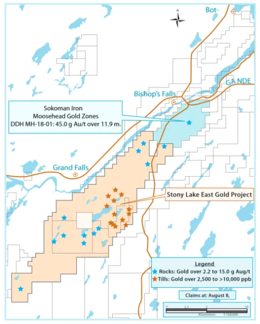
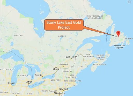
The project covers approximately 27 km of strike length of the Cape Ray/Valentine Lake trend between Sokoman’s (TSX.V: SIC) Moosehead discovery to the northeast and the Twilight zone discovery to the southwest.
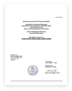
The historical exploration completed on the project is summarized in a National Instrument 43-101 Technical Report entitled “Compilation of Historical Geological, “Geochemical and Geophysical Exploration Work Carried out Over the Stony Lake Epithermal Gold Project, Grand Falls-Bishops Falls Area, Central Newfoundland” prepared by Larry Pilgrim, P. Geo as Qualified Person with an effective date of September 18, 2018.
The Stony Lake property has seen only cursory exploration for gold mineralization. Despite the numerous gold showings and highly anomalous gold geochemical results within and adjacent to the Project area, it was not until Sokoman’s Moosehead discovery that the area’s potential for gold mineralization was realized. Following the Moosehead discovery, several significant gold discoveries have been made in this portion of central Newfoundland.
Historical exploration activities on the Stony Lake project were sporadic and consisted of regional geochemical sampling, limited prospecting & sampling, 10 diamond drill holes (1,142m) on the Flyers Grid, and partial airborne geophysical coverage.
In addition to the Flyers’ area, historical exploration outlined six exploration targets within the Stony Lake property that exhibit a combination of some or all of the following:
- 18 known gold occurrences that exhibit epithermal style alteration and mineralization in bedrock/sub crop with rock grab sample results of up to 15.1 g Au/t,
- Soil, till and lake sediment sampling has identified multiple, coincident, large gold geochemical anomalies,
- Lower-grade (<4 g Au/t) auriferous alteration zones (argillic and silicification),
- Linear quartz-rich zones with gold concentration ranging from highly anomalous to gold values up to 15.1 g Au/t.
Stony Lake East NI 43-101
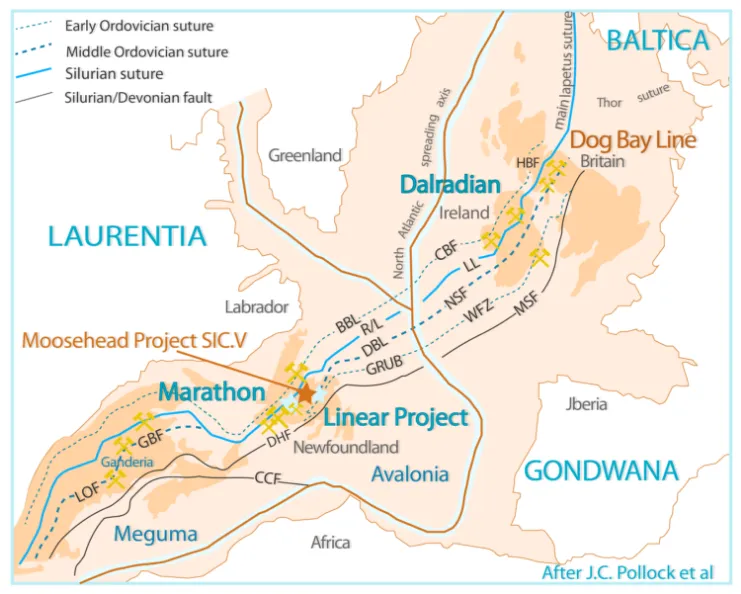
Regional Setting
The Stony Lake Property is located within an important regional structural zone striking through Southwest, Central and Northeast Newfoundland. This structural zone controls the distribution of gold mineralization in this part of Newfoundland. The region hosts Benton Resources Inc. (TSX.V: BEX)-Matador Resources (NYSE: MTDR) Cape Ray gold deposits, Quadro Resources (TSX.V: QRO) Staghorn gold zones, Marathon Gold’s (TSX: MOZ) Valentine Lake gold camp, Antler Gold’s (TSX.V: ANTL) recently discovered high-grade gold Twilight zone, Sokoman Minerals’ (TSX.V: SIC) new Moosehead gold discovery, as well as District Copper’s Stony Lake gold showings.
Sokoman Mineral’s Moosehead discovery to the northeast of the Stony Lake property has reported a significant number of high-grade gold intersections including:
- Drill hole, MH-18-01, (see SIC.V news release dated July 24, 2017) returned 11.9 m of 44.96 g Au/t from 109.0 m to 120.9 m,
- Drill hole MH-18-08 intersected 1.05 m of 207.1 g Au/t from 8.50 to 9.55m and 2.28m of 42.36 g Au/t from 33.07 to 35.35m (see SIC.V news release dated August 28, 2018), and
- MH-19-62 intersected 33.59 g Au/t over a4.80 m core length g (see SIC.V news release dated April 24, 2019).
Exploration Model:
The Cape Ray/Valentine Lake (“CRVL”) structural trend in central Newfoundland is Canada’s newest emerging orogenic gold district. The work completed to date by District on its Stony Lake project suggests that the CRVL trend has the potential to host a number of different styles of gold mineralization. The parameters that characterize the anomalous to low grade gold mineralization located on the Stony Lake property suggest the potential for a sediment hosted intrusion related gold environment. Sediment hosted intrusion related gold mineralization is characterized by faulted and folded siliciclastic rocks, granitic intrusions, regional scale faults, sericite with late carbonate alteration, mineralization hosted in sheeted veinlets, stockwork, disseminated and vein swarms and a gold, silver, bismuth, tungsten and molybdenum geochemical associations.
2019 Project Description/Results
The 2019 exploration program focussed on prospecting, mapping and sampling in the identified target areas and a property wide airborne magnetometer and radiometric survey to map bedrock lithologies, structural features and areas of structurally controlled potassic alteration. The airborne geophysical survey was completed in August 2019 and results are being compiled and interpreted with the final report expected in October 2019.
The results for the prospecting, sampling (286 samples) and mapping of lithologies, alterations, and styles of mineralization are summarized below. Selected samples were collected from outcrop, sub crop and large angular boulders (close to bedrock) to characterize the precious and base metals and trace element geochemistry present in veins, other mineralized structures and outcrops.
The 2019 program covered the northern portion of the property and have either expanded known zones of gold mineralization or identified new areas of highly anomalous to low grade gold mineralization. The mineralization in each zone remains open along strike.
The statistical data for gold and pathfinder elements for all samples collected in 2019 are listed in the table below.
table1
(ppb)=parts per billion, (ppm)=parts per million, detection limit for gold is 5 ppb, numbers in the above table have been rounded.
The statistical analysis by lithology for samples containing greater than 50 ppb gold are listed below.
table2
QFP=Quartz Feldspar Porphyry. The number in the above table have been rounded.
The distribution of the zones of anomalous (greater than 50 ppb) to low grade gold mineralization suggests that the zone lies within a northeast-southwest trending corridor located close to the western side of the property. Sampling to the west (Twin Pond area) and to the east (Moccasin Lake area) of the corridor returned low (less than 20 ppb) gold concentrations.
In the northeastern portion of the property, the areas of anomalous to low concentrations of gold mineralization are primarily underlain by a series of pyrite and arsenopyrite (1-3% total sulfide) bearing Quartz Feldspar, dikes, reduced sandstones and siltstones of the Wigwam formation and rare altered mafic dikes. To the southwest, the areas of anomalous to low grade gold mineralization are primarily underlain by reduced sedimentary rocks.
Pervasive silica and sericite alteration occur in all zones of anomalous to low grade gold mineralization. Sporadic chlorite, carbonate and ankerite (iron carbonate) alteration are more pronounced in the quartz veins and sheeted quartz veinlets. In places, the alteration is of an intensity to obliterate the original rock type. Pyrite and arsenopyrite are ubiquitous to all rock samples containing greater than 50 ppb gold. In rare instances stibnite and galena were also observed.
In the northern portion of the corridor; three northeast-southwest trending parallel zones (approximately 400m apart) of anomalous to low grade gold mineralization have been identified. The first zone (600m by 200m) is located on the recently acquired Duffitt claims. The second zone (1,600m by 600m) is located approximately 400m west of the Duffitt zone. The mineralization in both zones is also open to the northeast and southwest. The third zone located approximately 400m west of the second zone is a 6,000m long, linear northeast-southwest trend hosting five areas of anomalous to low grade gold mineralization. This zone is associated with a prominent northeast-southwest trending topographic lineament; a possibly fault zone. The results of the airborne survey should be helpful in confirming the presence of a fault underlying the mineralized corridor. The northeast end of zone 3 is referred to as the Rabbit Tracks area. The mineralization in the five areas within this corridor is open on strike.
To the southwest of Zone 3, the work completed around Frenchman’s Pond located anomalous to low grade gold mineralization over an area of 1,400m by 400m and in the area south of Tumbler Lake over an area of 400m by 200m. The mineralization in both zones remain open along strike to the northeast and southwest. Three other areas (2-3 samples) with anomalous gold values; Caters Pond (52-383 ppb gold), Island Pond (86-489 ppb gold) and Big Rocky Pond (801-4,026 ppb gold) have been identified that require additional prospecting and mapping. The south end of the property has not been prospected.
The geochemical signature accompanying the anomalous to low grade gold mineralization includes combinations of arsenic, antimony, tin and molybdenum.
The parameters that characterize the anomalous to low grade gold mineralization located on the Stony Lake property suggest the potential for a sediment hosted intrusion related gold environment. Sediment hosted intrusion related gold mineralization is characterized by faulted and folded siliciclastic rocks, granitic intrusions, regional scale faults, sericite with late carbonate alteration, mineralization hosted in sheeted veinlets, stockwork, disseminated and vein swarms and a gold, silver, bismuth, tungsten and molybdenum geochemical associations.
The next phase of the exploration of the Stony Lake property is contingent on the compilation of the results of the airborne survey, the 2019 sampling program and the historical geochemical and geological data. It is expected that this work will be completed by the end of September 2019.